Joseph H. Ammatelli

and 7 more

Benjamin Sullender

and 3 more

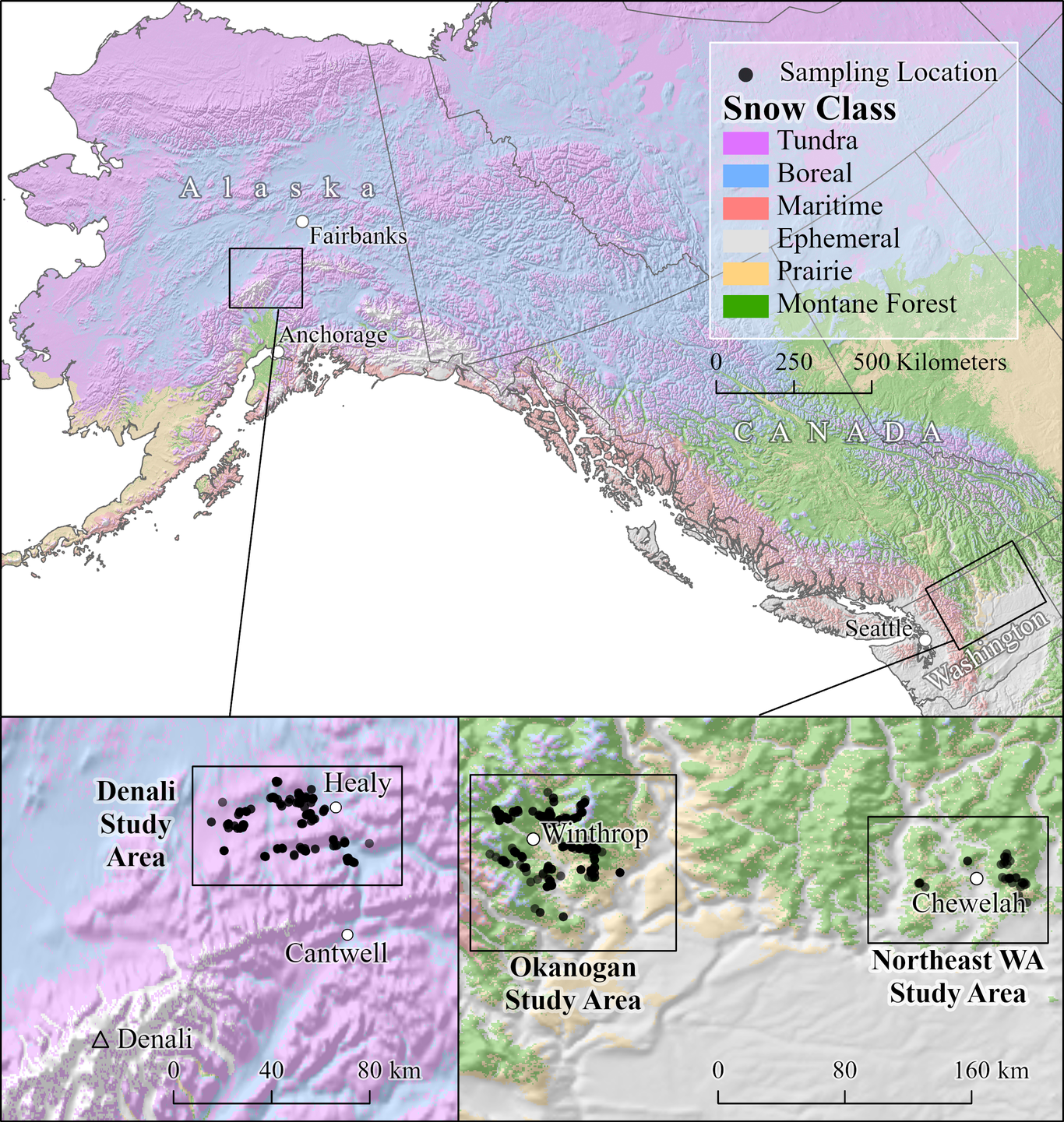
Snowpack dynamics have a major influence on wildlife movement ecology and predator-prey interactions. Specific snow properties such as density, hardness, and depth determine how much an animal sinks into the snowpack, which in turn drives both the energetic cost of locomotion and predation risk. Here, we quantified the relationships between 15 field-measured snow variables and snow track sink depths for widely distributed predators (bobcats [Lynx rufus], coyotes [Canis latrans], wolves [C. lupus]) and sympatric ungulate prey (caribou [Rangifer tarandus], white-tailed deer [Odocoileus virginianus], mule deer [O. hemionus], and moose [Alces alces]) in interior Alaska and northern Washington, USA. We first used generalized additive models to identify which snow metrics best predicted sink depths for each species and across all species. For species occurring in both sites, we then tested whether the snow metric-sink depth relationship differed across regions. Finally, we used breakpoint regression to identify thresholds for the best-performing predictor of sink depth for each species (i.e., values wherein tracks do not appreciably sink into the snow). Near-surface (0-10cm) snow density was the strongest predictor of sink depth across species. This relationship varied slightly by region for wolves and moose but did not differ for coyotes. Thresholds of support occurred at snow densities of 230 kg/m3 for coyotes, 280 kg/m3 for bobcats, 290 kg/m3 for wolves, 340 kg/m3 for deer, 440 kg/m3 for caribou, and 550 kg/m3 for moose. Together, these critical thresholds define the bounds of “danger zones,” the range of snow density in which carnivores have a comparative movement advantage over ungulates. These results can be used to link predator-prey relationships with spatially explicit snow modeling outputs and projected future changes in snow density. As climate change rapidly reshapes snowpack dynamics, these danger zones provide a useful framework to anticipate likely winners and losers of future winter conditions.

Justin Pflug

and 2 more

The magnitude and spatial heterogeneity of snow deposition are difficult to model in mountainous terrain. Here, we investigated how snow patterns from a 32-year (1985 – 2016) snow reanalysis in the Tuolumne, Kings, and Sagehen Creek, California Sierra Nevada watersheds could be used to improve simulations of winter snow deposition. Remotely-sensed fractional snow-covered area (fSCA) from dates following peak-snowpack timing were used to identify dates from different years with similar fSCA, which indicated similar snow accumulation and depletion patterns. Historic snow accumulation patterns were then used to 1) relate snow accumulation observed by snow pillows to watershed-scale estimates of mean snowfall, and 2) estimate 90 m snow deposition. Finally, snow deposition fields were used to force snow simulations, the accuracy of which were evaluated versus airborne lidar snow depth observations. Except for water-year 2015, which had the shallowest snow estimated in the Sierra Nevada, normalized snow accumulation and depletion patterns identified from historic dates with spatially correlated fractional snow-covered area agreed on average, with absolute differences of less than 10%. Watershed-scale mean winter snowfall inferred from the relationship between historic snow accumulation patterns and snow pillow observations had a ±13% interquartile range of biases between 1985 and 2016. Finally, simulations using 1) historic snow accumulation patterns, and 2) snow accumulation observed from snow pillows, had snow depth coefficients of correlations and mean absolute errors that improved by 70% and 27%, respectively, as compared to simulations using a more common forcing dataset and downscaling technique. This work demonstrates the real-time benefits of satellite-era snow reanalyses in mountainous regions with uncertain snowfall magnitude and spatial heterogeneity.

Jessica Lundquist

and 5 more

When formulating a hydrologic model, scientists rely on parameterizations of multiple processes based on field data, but literature review suggests that more frequently people select parameterizations that were included in pre-existing models rather than re-evaluating the underlying field experiments. Problems arise when limited field data exist, when “trusted” approaches do not get reevaluated, and when processes fundamentally change in different environments. The physics and dynamics of snow interception by conifers, including both loading and unloading of snow, is just such a case. The most commonly used interception parameterization is based on data from four trees from one site, but field study results are not directly transferable between environments. The process varies dramatically between locations with relatively warmer versus colder winters. Here, we combine a comprehensive literature review with a model to demonstrate essential improvements to model representations of snow interception. We recommend that, as a first and essential step, all models include increased loading due to increased adhesion and cohesion when temperatures rise from -3 and 0°C. The commonly used parameters of a fixed maximum value for loading and an e-folding time for unloading are not supported by observations or physical understanding and are not necessary to reproduce observations. In addition to unloading based on physical processes, such as wind or canopy warming, all models must represent melting of in-canopy snow so that it can be unloaded in liquid form. As a second step, we propose field experiments across climates and forest types to investigate: a) a representation of the force balance between adhesion and cohesion versus gravity for both interception efficiency and rates of unloading, b) wind effects during and between storms, and c) lubrication when snow melts. For greatest impact, this framework requires dedicated field measurements. These processes are essential for models to accurately represent the impacts of dynamically changing forest cover and snow cover on both global albedo and water supplies.