Shlomy Vainer

and 9 more

The Kalahari Basin in southern Africa, shaped by subsidence and epeirogeny, features the Okavango Rift Zone (ORZ) as a significant structural element characterized by diffused extensional deformation forming a prominent depocenter. This study elucidates the Pleistocene landscape evolution of the ORZ by examining the chronology of sediment formation and filling this incipient rift and its surroundings. Modeling of cosmogenic nuclide concentrations in surficial eolian sand from distinct structural blocks around the ORZ provides insights into sand’s residence time on the surface. Sand formation occurred from ~2.2 to 1.1 Ma, coinciding with regional tectonic events. Notably, provenance analyses of sand within ORZ’s lowermost block where large alluvial fans are found indicate different source rocks and depositional environments than those of the more elevated eolian sand. This suggests that the major phase of rift subsidence and the following incision of alluvial systems into the rift occurred after eolian dune formation. Luminescence dating reveals that deposition in alluvial fan settings in the incised landscape began not later than ~250 ka, and that a lacustrine environment existed since at least ~140 ka. The established chronological framework constrains the geomorphological effects of the different tectono-climatic forces that shaped this nascent rifting area. It highlights two pronounced stages of landscape development, with the most recent major deformation event in the evolving rift probably occurring during the middle Pleistocene transition (1.2-0.75 Ma). This event is reflected as a striking change in the depositional environments due to the configurational changes accompanying rift progression.

Sebastien J.P. Lenard

and 13 more

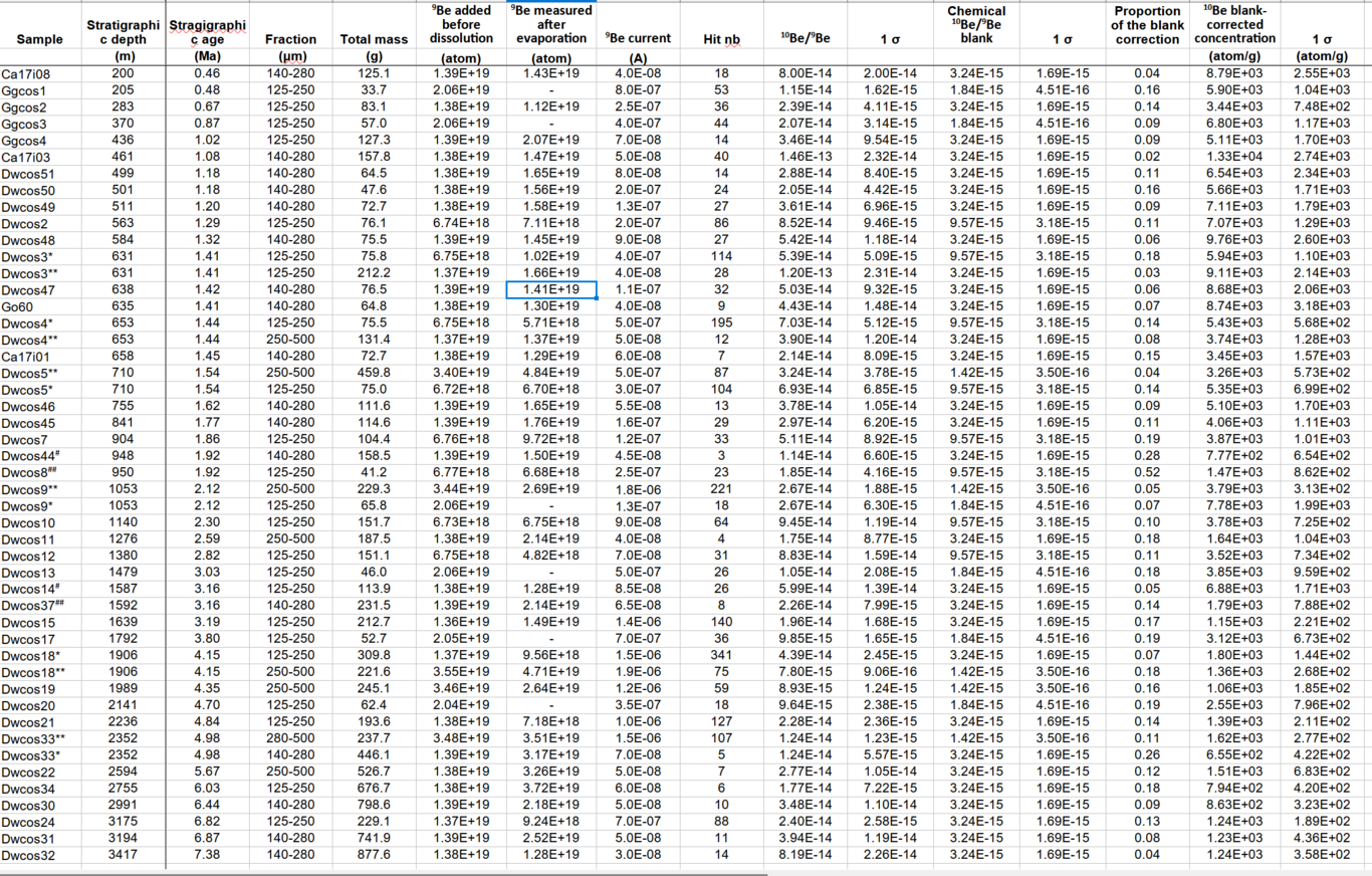
The Glaciations impacted erosion during the Late Cenozoic but no consensus has emerged whether they led to increased erosion rates globally. In the Himalayas, recent work used past sediment concentrations of the terrestrial cosmogenic nuclide (TCN) 10Be and demonstrated that erosion rates have not permanently increased in the Himalayas. However, for the Quaternary, the published sedimentary records suffer from provenance uncertainties which prevent to elaborate on the causes of steady erosion rates. Here, we document the new, 4,000-m thick Valmiki Section (VS) to address this question. In the remote Valmiki Tiger Reserve, the VS consists of Siwalik sediment deposited in the Himalayan foreland basin by the Narayani River, a major river of Central Himalayas. To quantify past Himalayan erosion rates from TCN 10Be measurements, we determine: (1) the magnetostratigraphic deposition age model, (2) provenance using major elements and Sr-Nd isotopes, and (3) the recent cosmic exposure related to Siwalik exhumation using TCN 36Cl measurement in feldspar. The VS records Himalayan erosion from 7.5 to 1.25 Ma. Our 10Be results confirm steady erosion rates, close to modern values, 1.4-2.3 mm/y, with a brief increase by 35% at 2 Ma, possibly due to sustained glacial erosion of the high peaks as suggested by the geochemical signature. The Narayani Catchment may be more sensitive to the onset of the Glaciations because of larger glacial cover (presently ~10%) than elsewhere in the Himalayas. Despite this sensitivity, our results support that over long timescales, rather than climate, tectonics control Himalayan erosion.